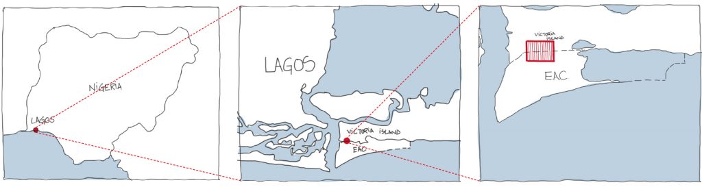
Why Lagos?
Aside being the economic hub on the African continent, Nigeria is one of Africa´s fastest growing cities and the second most populated Megacity in Africa. Like many other coastal cities, Lagos is highly vulnerable to flooding and coastal erosion owing to increasing mean sea level rise due to climate change.
Lagos is also susceptible to high urban heat risk in the current and future climate due to her tropical climate location. Thus, there is a clear need to better understand the urban heat and human comfort of cities like Lagos, to better inform their adaptation and mitigation needs. To resolve both flood risk and housing deficits issues currently facing the city, the Eko Atlantic City (EAC) vision was conceived. EAC is new mixed-use development to be built on land reclaimed from the sea, with effective flood defences, and would house at least 250,000 residents upon completion. Several skyscrapers are planned to be built on the sand-filled area. The ambitious project is intended to create a new financial centre in Africa. In addition, housing for about 300,000 people is to be created and 150,000 new jobs are to be created, relieving the pressure on the rapidly growing megacity of Lagos.
This academic study, based on the ENVI-met software tool, attempts to make a first step towards answering key environment-related question in regards to the planned of EAC, like the potential microclimatic effect of the development on the existing adjacent neighbourhood or which proven strategies can help to support the microclimatic conditions of the new city.
This academic study, based on the ENVI-met software tool, attempts to make a first step towards answering key environment-related question in regards to the planned of EAC, like the potential microclimatic effect of the development on the existing adjacent neighbourhood or which proven strategies can help to support the microclimatic conditions of the new city.
Results
Nigeria’s population would not stop growing shortly, so also, Lagos’ population explosion could continue reaching about 80 million by 2100 according to projections. On the other hand, future climate projection has suggested increased temperatures with higher frequency and intensity of extreme temperatures e.g. Heatwaves. Densely populated tropical cities of the magnitude of Lagos are at high urban heat risk and therefore require a better understanding of the risk dynamics and requisite sustainable actions for mitigation and adaptation.
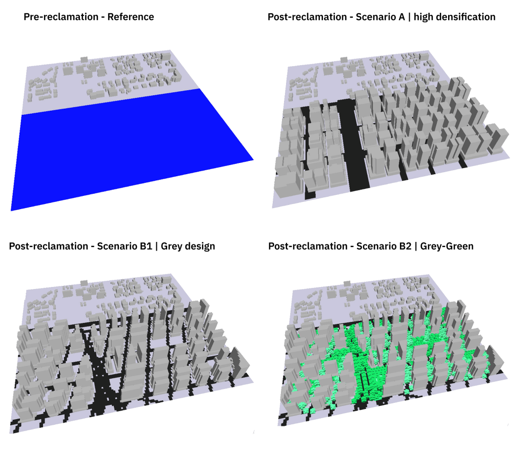
Climate-sensitive urban planning and development is the integration of climate-proofing strategies e.g., land use planning, inclusion of green-wind corridors, passive grey design implementation (e.g. urban geometry design, urban morphology optimization), and strategic urban greening into the urban development process to mitigate intense urban heat by reducing the thermal load and enhancing air ventilation in the urban environment.
The current urban renewal project of Lagos does not include such specific proven climate-informed strategies in the urban developmental framework or guidelines even though certain actions such as the Lagos Park’s project are contributing to urban heat adaptation. There are several opportunities to scale up the urban heat mitigation across the megacity. While there are challenges in retrofitting existing and already developed sections of the city, veritable strategies to climate-proof the city at the building, neighbourhood and city scales should not be neglected but rather infused into the development process from planning to construction phases. The benefits of such actions are not only felt local but can be transported to downwind neighbourhoods.
This was particularly the key finding of this research which investigates the potential micro-climatic impact of the conversion of the large ocean surface to a built-up area, locally in the new development and downwind in the existing neighbourhood. Through microclimate simulation with ENVI-met, it was proved that creating a new area certainly has a lot of challenges – when replacing the ocean with built-up areas it will worsen the microclimate in situ but also downwind.
The results revealed both the in situ and downwind areas became warmer both at day and night-time due to significant (about 50%) landcover change from water to the paved built-up surface. It was also found that depending on the urban structure and design features imposed on the reclaimed area, the intensity of the consequent daytime and night-time warmth and thermal discomfort varies across the study domain.