
Ying Zheng
2nd Place
Ying Zheng is currently doing her PhD at the Queen’s University Belfast, UK with the subject Environmental Planning. Her PhD research focuses on nature-based solutions for urban heat island in megacities. Before she studied Landscape Design at Dalian Polytechnic University, China and completed her studies with a Master’s degree.
Laudatio for Ying Zheng
“The project aims to evaluate the cooling effects of greening on urban microclimate in high density context in Shenzhen, China. This research explores the potential of urban greening strategies to improve the urban microclimate quality. The project was developed in UK and took three years. The process offered a hybrid 3D visualization research method using software combination of Rhino7, Dragonfly and ENVI-met, and it used the Shenzhen climatic data correctly.
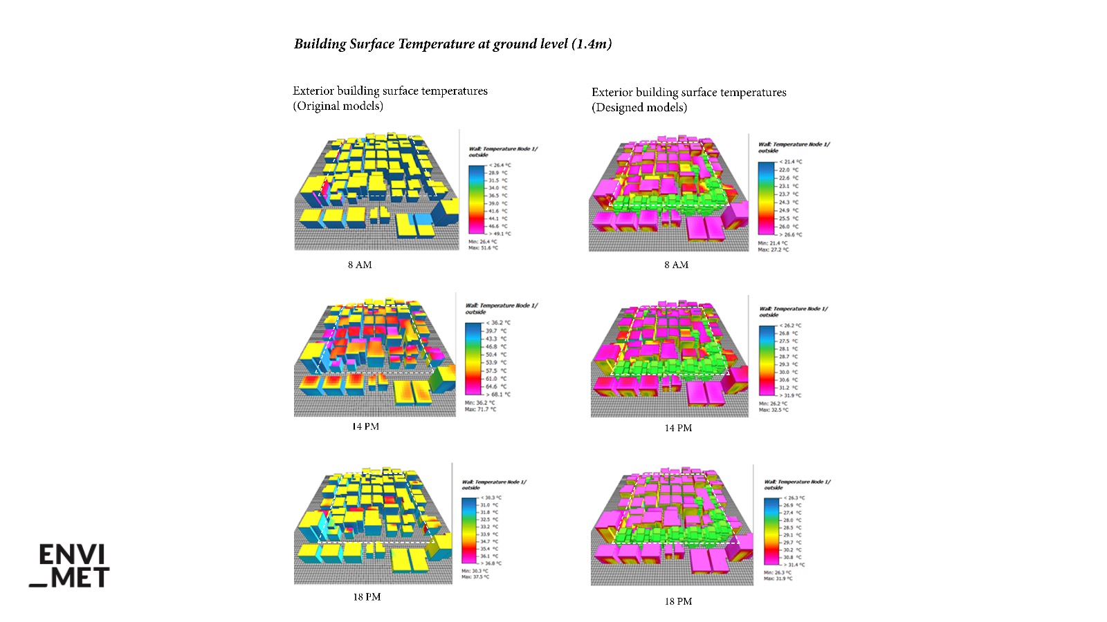
Ying Zheng explores nature-based solutions and their effects in two distinct approaches: pedestrian and building. For this analysis, the research explores thermal comfort using Predicted Mean Vote and exterior building temperatures. The combination of graphs and figures represents a holistic way to demonstrate and clarify the advances of this type of study.”
Caio Frederico E Silva
Associate Professor at the University of Brasilia (Brazil), Coordinator of the Architecture and Urbanism Post-graduation Program. Associate researcher of the University Nova de Lisboa (Portugal). Collaborator Researcher of the Critical Landscapes Design Lab (Graduate School of Design – Harvard University)
Evaluating the cooling effects of greening on urban microclimate in high density urban area

Why Shenzhen?
Shenzhen is a continuously expanding megacity with a population of 17 million permanent residents in 2020 (Shenzhen Bureau of Statistics, 2021). In four decades from 1978 to 2018, Shenzhen has growth from a fishing village to a global innovation metropolis, and it made world history with its rapid development. Shenzhen as a case study, several characteristics are listed below:
1. Shenzhen was designated the earliest Special Economic Zone in China. As an experimental district, this city is an ideal case for research to China’s urban development.
2. Shenzhen has a large migrant population outweighs the permanent residents. Most migrants live in urban villages, which are vital to urban construction of Shenzhen.
3. Shenzhen has noticeable urban heat island effect. Regulating local urban climate by urban greening not only helps the city deal with high temperatures or heat waves but also guides other fast-urbanizing regions to construct resilient cities.
Urban villages (chengzhongcun by Chinese) are a phenomenal case in Shenzhen’s urbanisation. In these villages, buildings are called “handshake buildings” because of the high density. The overwhelming density thus created issues such as no vegetation coverage, poor sanitary conditions, overcrowded population, and environmental pollution.
The existence of these environmental issues has caused changes in the microclimate environment in these villages, giving rise to the Urban Heat Island effect (UHI). The UHI is an urban area has much warmer temperature than the surrounding area due to human activities.
A case study area, one of the community in the Baishizhou area that has the highest density without planting in Shenzhen, China, used for design and environmental simulation assessment.Currently, this area faces the most typical and urgent social and environmental problems regarding morphological diversity, building intensification, population structure, media exposure, and research attention.


Results
This study develops a hybrid method for microclimate simulation to evaluate urban microclimate using the software combination of Rhino7, Dragonfly and ENVI-met. This method was used to simulate the microclimate in a high-density residential area.
A typical summer day, August 09, was simulated by using a hybrid 3-D visualisation research method. The resulting microclimate data at 8 a.m., 2 p.m. and 6 p.m. were generated and analysed, since the study involves observing the changing of microclimate at different time periods within a hot summer day. Different data were analysed to study the microclimate and human thermal comfort conditions at the ground level (1.4m) while using a typical human subject used to calculate PMV, in this case a 35-year-old male, 1.75m in height, 75kg in weight, with a clothing index of 0.9, and a metabolic rate of 86.21W.
The results demonstrate that high building density has a serious negative impact on microclimate and urban greening can contribute positively to the cooling effect, providing outdoor thermal comfort. For instance, due to the high building density, the pathways in the area are in shadow. As a result, the vertical greenery design has limited effect in cooling the pathway between buildings within the area. Besides, it can be found from the wind speed simulation results that, since the distance between the buildings in the area is narrow, it is difficult for the air to pass through smoothly. Thus, the wind speed between buildings is close to zero at ground level (1.4m).
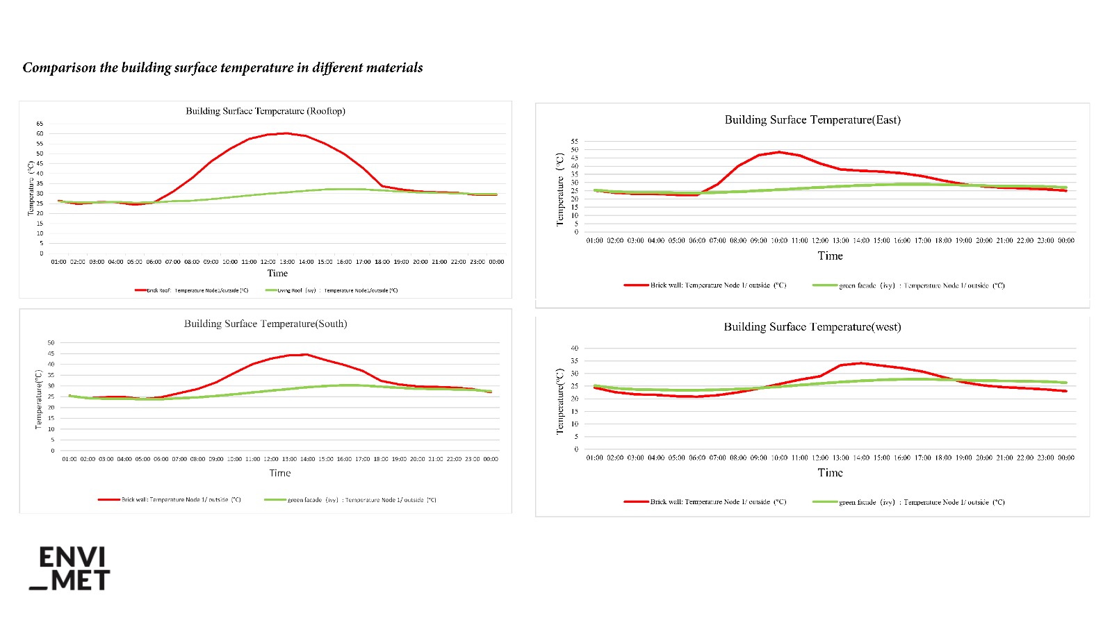
Ivy is the most effective climber for cooling buildings, reducing humidity and mean radiant temperature. For example, compared to data before design, point C of the designed area has a 10% lower relative humidity, and a 17°C lower mean radiant temperature at 2 p.m. Moreover, the use of green roofs and green walls can have a significant impact on the cooling effect within a given building. The results show that the green roofs have a maximum cooling effect up to 30°C on the exterior surfaces of the building on the test day.
Urban greening systems design will improve the microclimate of the area, especially for outdoor thermal comfort. Shades of plants have a strong potential to interact with the thermal performance of building material. Shade provided by trees or other objects reduces building surface temperatures on summer days. The PMV of the designed scenario is significantly lower than the original value in the hottest time.
Besides, this method can help to incorporate the implementation of greening schemes in downtown development and visualize the potential cooling benefits of different design scenarios. Therefore, it has a significant contribution to analyse and visualize the potential cooling effect of different greening design scenarios to support design decision-making. The future study will continue to test out the most suitable greening systems and plant species to mitigate environmental damages and urban heat island effects in megacities.